|
|
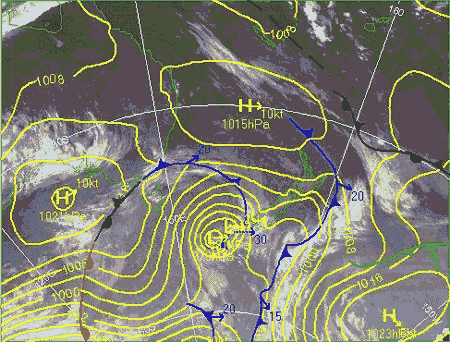
A cold front is
the leading edge of a invading colder air-mass and
is marked by a line with triangles pointing to
where it is moving.
Cold fronts push in underneath
the warmer air ahead of them, forcing the warm air
upwards and making cloud and areas of
rain.
As a cold front passes by: any
rain clears but showers may appear, humidity drops,
air temperature usually drops, pressure rises and
the wind changes direction.
|

|
|
A warm front is
the leading edge of an invasion of warmer air. Its
surface position is marked by a line with
semicircles pointing to where it is moving.
The advancing warm air rises
over a zone of retreating cooler air, making a
cloud bank that slopes forwards from ground level
upwards, often bringing prolonged steady rain.
As a warm front passes by: any
rain becomes patchy but humidity remains high, air
temperature may rise a little, pressure steadies,
and the wind changes direction.
|

|
|
An occluded
front or occlusion occurs when a cold front
overtakes a warm front, so that all that remains of
the original warm air is trapped above, where it
cools making dense cloud and rain.
It is marked by a line with
triangles and semicircles on the same side,
pointing to where the front is moving.
As an occluded front passes by:
any rain becomes patchy, wind eases, the rate of
pressure fall may level out but air temperature
does not change much.
|

|
|
A
stationary front is one which has slowed right
down, so that neither air-mass is making much
progress.
It is marked by a line with
alternate triangles and semicircles on opposite
sides ... the triangles protruding into the warmer
air-mass and the semicircles protruding into the
cooler air-mass.
It takes a while for a
stationary front to pass by: any rain clears only
slowly and temperature and pressure do not change
much.
|

|
|
