|
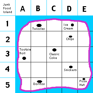
For example, this map shows where you can
find different kinds of junk food.
How could you tell someone how to pick up
an icecream, and then a pizza? You could do it in words, but
it would be quite complicated.
A map makes it easier by having a grid.
The island is broken up into small squares, and each one has
a horizontal reference (numbers 1 to 5) and a vertical
reference (letters A to E).
The icecream is at D1. The pizza is at
E5. What an easy way to describe where places
are!
Real maps use numbers, and the horizontal
reference is the latitude, and the vertical is the
longitude.
But road maps use letters and numbers
like this.
|
