|
We can use a technology called imaging radar to help create a picture of the terrain on Earth--or any other planet. Imaging radar instruments are either flown over the land (or water) in an airplane, flown in space on the Space Shuttle, or put on a spacecraft and launched into orbit around the planet. |
|
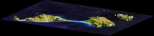
This image was made from Shuttle Radar Topography Mission data. It shows two islands, St. Pierre and Miquelon, near Newfoundland, Canada. Miquelon is in two parts, separated by a narrow strip of beach. Notice that the SRTM data shows the heights of the islands. |
|
The Shuttle Radar Topography Mission (SRTM) |
|
|
|
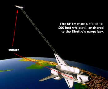 was
flown aboard the Space Shuttle Endeavour in February 2000.
It passed over almost every point on Earth. It made radar
images that scientists will use to make the best topo map
ever made of Earth. It will take scientists a long time to
study all the image data and up to two years to make the
map.
was
flown aboard the Space Shuttle Endeavour in February 2000.
It passed over almost every point on Earth. It made radar
images that scientists will use to make the best topo map
ever made of Earth. It will take scientists a long time to
study all the image data and up to two years to make the
map.|
|
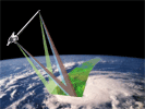
SRTM is actually two radars. They are on opposite ends of a long mast that unfolded from its container in the cargo bay of the Shuttle Endeavour. This structure is the largest ever to fly in space. |
|
|
|
|
|
|
|
|
|
|||||