|
"See" Inside a Closed Box!
|
|
Imagine being able to make a detailed map of an object you can't even see. Suppose someone shows you a box and says it contains a mysterious object. Figure out what's in the box without looking or touching and the object is yours! The box has no lid, but is covered by a piece of paper so you can't see inside. You are allowed to poke small holes in the paper with a sharp, straight stick of some kind, like a long skewer or knitting needle, but you can't peek inside. How would you discover what's in the box?  Well, one way is to poke the stick straight down into the box until it touches something. Mark with your fingers how far the stick went in. Take out the stick and measure how far it went into the box. Mark that hole with that measurement. You could use numbers for the measurements, but an easier way is to use colors. For example, 5 inches deep is blue, 6 inches is purple. 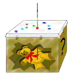 After you have almost covered the paper with color-coded holes, you could color in the areas with same-colored holes. You would then have a topograhical map of the object inside the box! You might not be able to tell exactly what the object is even from its "topo" map. But, if you know what colors stand for what heights, you could imagine how the object might look in three dimensions. 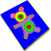
Radar is a kind of light energy, but we can't see it. It also acts like sound, because it bounces off surfaces making "echoes," which are "heard" by the radar antenna.
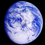
We know how fast the radar signal travels in air, so if we time how long it takes for the signal to return, we can figure out how far it traveled and use this information to get a picture of the surface. It turns out that if we use two radars at the same time and do special calculations, we not only find out if the surface has mountains or valleys, we can actually measure how high or low they are. When we have this information, we can make detailed 3-dimensional (3-D) or topographical ("topo") maps. The Space Shuttle Radar Topography Mission in February 2000 did just that. As the Space Shuttle orbits around Earth, radar instruments inside and outside the Shuttle made a 3-D map of almost the whole world. In just 11 days, this mission produced enough information to fill 20,000 CDs! It will take scientists a year and a half to process it all into maps. You can read more about the Shuttle Radar Topography Mission on another Space Place page.
The information from the two radars is processed in a special way so the map from them is more accurate than the map from just one radar. The improved maps will be used by a lot of different people to help them do their jobs better. Pilots will know how high a mountain is even when they can't see it. Hikers will have better topo maps to use in new places, so the maps will also be used just to help us have more fun. Isn't it amazing what we can do once we understand some simple things about light and radar waves? |
 Like
the paper that hides our Teddy bear, clouds often hide large
areas of the Earth's surface. But, just as we can map the
bear through the paper, we can use radar to make detailed
maps of Earth right through clouds or darkness.
Like
the paper that hides our Teddy bear, clouds often hide large
areas of the Earth's surface. But, just as we can map the
bear through the paper, we can use radar to make detailed
maps of Earth right through clouds or darkness.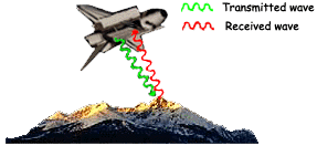 When radar bounces off the ground, only some of the signal
gets back to where it started. Much of the signal scatters
in other directions. How much of the signal scatters depends
on how smooth or rough the surface is--whether it is covered
with smooth water or rough trees, for example--or whether
the surface is flat or slanted--like deserts or mountains,
or farmlands or cities.
When radar bounces off the ground, only some of the signal
gets back to where it started. Much of the signal scatters
in other directions. How much of the signal scatters depends
on how smooth or rough the surface is--whether it is covered
with smooth water or rough trees, for example--or whether
the surface is flat or slanted--like deserts or mountains,
or farmlands or cities. The
two radars of the Shuttle Radar Topography Mission are held
far apart by a long mast on the Space Shuttle. The radar
antenna that is inside the Space Shuttle sends a signal down
to the ground and then both the radar in the Shuttle and the
one outside the Shuttle "listen" for the
"echoes."
The
two radars of the Shuttle Radar Topography Mission are held
far apart by a long mast on the Space Shuttle. The radar
antenna that is inside the Space Shuttle sends a signal down
to the ground and then both the radar in the Shuttle and the
one outside the Shuttle "listen" for the
"echoes."|
|
|
|
|
|
|
|
|
|||||